Table of Contents >> Show >> Hide
- The Big Picture: A Warmer, Drier Spring for Much of America
- Spring 2026 Weather Predictions by U.S. Region
- How Does The Old Farmer’s Almanac Predict Spring Weather?
- How Accurate Are Almanac Weather Predictions?
- What Actually Happened During Spring 2026?
- How to Use Spring Weather Predictions Without Outsmarting Yourself
- A Practical Spring Experience: Planning Around a Long-Range Forecast
- Conclusion
Spring weather has always had a flair for drama. One afternoon, you are drinking iced tea on the porch; the next morning, you are scraping frost from the windshield while questioning every life decision that led you to pack away your winter coat.
For spring 2026, The Old Farmer’s Almanac predicted a broadly warmer and drier pattern across much of the United States during April and May. However, the outlook was not one giant nationwide promise of sunshine. Cooler pockets were expected in parts of the Northwest and northern Rockies, while several interior regions were forecast to receive above-normal precipitation.
Here is a detailed look at the Almanac’s spring weather predictions, what they meant region by region, how seasonal outlooks should be interpreted, and how the forecast compared with conditions ultimately recorded by federal climate scientists.
The Big Picture: A Warmer, Drier Spring for Much of America
The headline from The Old Farmer’s Almanac was fairly straightforward: most Americans could expect spring temperatures to average above normal, while rainfall would generally fall below historical averages.
The major temperature exceptions included Washington, Oregon, Idaho, and portions of Montana and Colorado. These areas were expected to remain closer to normal or occasionally dip below normal, especially during parts of May.
Rainfall predictions were more complicated. Although dry spells were expected across much of the country, wetter conditions were forecast for parts of Alaska, Texas and Oklahoma, the northern Appalachians, the High Plains, the Upper Midwest, and the Intermountain West.
That distinction matters. A “warmer and drier” seasonal forecast does not mean every day will be warm or that rain will disappear for two months. It means that when temperatures and precipitation are averaged across the forecast period, they are expected to finish on one side of the historical norm. A single week of thunderstorms can still interrupt a generally dry season with all the subtlety of a marching band entering a library.
Spring 2026 Weather Predictions by U.S. Region
Northeast and New England
The Northeast was expected to enjoy a warmer-than-average spring, with May temperatures in parts of New England forecast to average approximately 3 degrees Fahrenheit above normal. Rainfall was predicted to remain below average in both April and May, with no significant late-season snowfall anticipated.
That combination sounded appealing to homeowners eager to retire their snow shovels. Gardeners, however, still needed to consider frost risk. Warm average temperatures do not eliminate the possibility of one badly timed cold night visiting the tomatoes like an uninvited relative.
Atlantic Corridor and Appalachians
From the Boston-to-Richmond coastal corridor, the Almanac anticipated warmer conditions, with rainfall becoming closer to normal during May. The Appalachian region was also expected to be warmer than usual, but precipitation varied geographically.
Northern Appalachian areas were among the wetter exceptions in the national outlook, while some northeastern portions of the region could experience below-normal rainfall. The southern Appalachians were generally expected to receive more precipitation.
Upper Midwest and Great Lakes
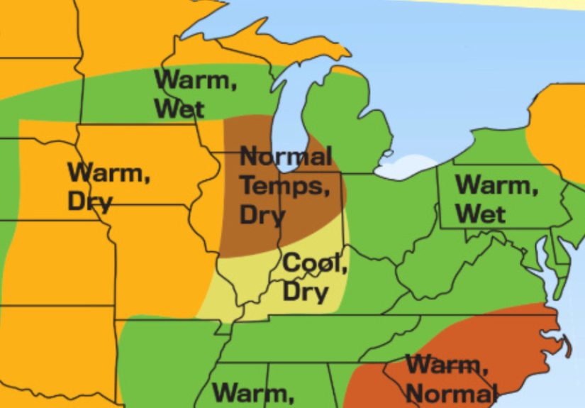
The Upper Midwest received one of the more divided forecasts. Eastern sections were expected to be cooler and drier, while western portions leaned warmer and wetter. Areas surrounding the lower Great Lakes were generally forecast to be warmer, with wetter conditions toward the west and drier weather farther east.
This kind of split forecast is a reminder that regional boundaries are not invisible weather walls. A storm system does not reach the edge of a map, inspect the legend, and politely turn around. Residents near forecast boundaries should pay particular attention to updated local outlooks.
Heartland and Ohio Valley
Much of the central Heartland was forecast to have a warm spring. April temperatures in some areas were predicted to average around 5 degrees above normal. Rainfall was expected to be lower in northern sections and higher across southern areas.
The Ohio Valley also leaned warm, but precipitation predictions varied considerably. Southern Illinois and Indiana were expected to be drier, while southern Ohio and West Virginia had better chances of above-normal rainfall.
Texas and Oklahoma
Texas and Oklahoma were among the country’s wetter exceptions. The Almanac forecast a notably warm Aprilapproximately 5 degrees above normal in some placesfollowed by more variable temperatures in May. Northern areas could cool below normal, while southern areas were expected to remain slightly warmer.
Rainfall was predicted to finish above normal, and the Almanac even raised the possibility of tropical activity influencing the region late in May. That was not a promise that a named storm would arrive at a particular address. It was a broad signal that residents should remain ready for periods of heavy rain and changing conditions.
Southeast, Deep South, and Florida
The Southeast was predicted to have a warmer-than-normal spring. April leaned drier, while May was expected to turn wetter. In the Deep South, precipitation was forecast to be higher across northern areas and lower toward the south.
Florida also leaned warmer. April was predicted to be drier than usual, with rainfall moving closer to normal in May. For gardeners and landscapers, that suggested a need to watch soil moisture early in the season rather than trusting the famous phrase about April showers to handle all watering responsibilities.
High Plains and Northern Rockies
The High Plains, stretching through parts of the central United States, were forecast to be warmer overall, with April particularly warm in some locations. Unlike many other regions, however, the High Plains were expected to receive above-normal precipitation.
Parts of Montana and Colorado represented exceptions to the national warmth. Temperatures there could stay closer to normal or occasionally fall below average. Late cold snaps remained possible, especially at higher elevations where spring occasionally arrives, looks around, and decides to come back next week.
Pacific Northwest
Washington, Oregon, and Idaho were expected to experience one of the coolest regional patterns in the Almanac’s forecast. April temperatures were generally projected to remain near normal. During May, northern areas could turn cooler while southern sections became warmer.
Despite the cooler tendency, the Pacific Northwest was broadly expected to be drier than normal. That combination could affect snowmelt, soil moisture, reservoir inflows, and the timing of gardening or outdoor construction projects.
Pacific Southwest and Desert Southwest
The Pacific Southwest was forecast to be warmer and drier than usual. The Desert Southwest was expected to have a warmer April followed by a more seasonable May, with dry conditions remaining a concern.
In these regions, a dry spring can provide excellent hiking and outdoor-event weather while simultaneously increasing irrigation demands and worsening vegetation dryness. Sunshine is wonderful until the garden begins making crunchy noises.
Alaska and Hawaii
The Almanac forecast warmer-than-normal temperatures for much of Alaska, with wetter conditions in the north and below-normal precipitation in southern areas. Hawaii was also expected to be warmer, with below-normal rainfall in eastern areas and wetter conditions across parts of the central and western islands.
As always, statewide summaries can hide major local differences. Elevation, exposure to prevailing winds, nearby water, and terrain can produce dramatically different conditions within relatively short distances.
How Does The Old Farmer’s Almanac Predict Spring Weather?
The Old Farmer’s Almanac has published weather predictions since 1792. Its long-range method combines solar science, climatology, meteorology, historical patterns, and a proprietary forecasting formula associated with founder Robert B. Thomas.
The Almanac compares predicted temperatures and precipitation with long-term regional averages. It then describes each period using broad departures such as warmer, cooler, wetter, or drier than normal.
This differs from the forecasting process behind a seven-day weather app. Short-range forecasts continually ingest new satellite observations, radar data, weather-balloon readings, surface measurements, and computer-model output. A seasonal forecast cannot tell you whether it will rain during a Saturday wedding six weeks from now. It can only offer a broad indication of which climate outcome may be favored.
NOAA’s seasonal outlooks are also probabilistic. They estimate whether the average temperature or precipitation for a month or season is more likely to fall within the upper, middle, or lower third of the historical record. They do not predict exact rainfall totals or guarantee that every week will follow the seasonal pattern.
How Accurate Are Almanac Weather Predictions?
The Almanac traditionally promotes an average accuracy rate near 80 percent. However, its scoring methods and the broad nature of its regional predictions have received criticism from meteorologists.
One important detail is that accuracy may be evaluated by determining whether the Almanac correctly predicted the general direction of temperature or precipitation departure for a representative location. That is a much broader target than predicting specific temperatures, rainfall totals, or storm dates.
The Almanac has also acknowledged seasons in which its performance fell below its traditional claim. A frequently cited University of Illinois analysis of five years of forecasts found results near 50 percent for the direction of monthly temperature and precipitation departuresroughly comparable to chance.
The fairest approach is neither to treat the Almanac as meteorological scripture nor dismiss it as decorative bookshelf material. Its outlook can be useful as an early planning signal, provided it is combined with NOAA outlooks, local climate information, frost records, and frequently updated National Weather Service forecasts.
What Actually Happened During Spring 2026?
Because spring 2026 has now ended, NOAA’s recorded climate data provides an unusually helpful reality check.
Across the contiguous United States, meteorological springMarch through Mayaveraged 55.8 degrees Fahrenheit. That was 4.9 degrees above the 20th-century average, making it the second-warmest spring in 132 years of records. Every contiguous state experienced above-average temperatures, and 20 states averaged at least 5 degrees above their historical spring mean.
Precipitation across the contiguous United States totaled 7.43 inches, approximately half an inch below average. That placed the season within the driest third of the historical record.
On the broadest national level, those results resembled the Almanac’s warmer-and-drier headline. Regional performance was far less uniform. Parts of the Midwest and Great Lakes were unusually wet, with Michigan recording its wettest spring on record. Much of the West, Southwest, Rockies, and western Plains was particularly dry. North Carolina and Delaware each experienced their third-driest spring.
There is also an important timing difference: the Almanac’s primary spring forecast focused on April and May, while NOAA’s meteorological spring statistics cover March, April, and May. March 2026 was exceptionally warm, becoming the warmest March on record for the contiguous United States. Therefore, the national seasonal average is not a perfect one-to-one test of the Almanac’s April–May prediction.
How to Use Spring Weather Predictions Without Outsmarting Yourself
Use the Outlook for Flexible Planning
A seasonal prediction is useful when choosing a general planting window, estimating irrigation needs, scheduling outdoor maintenance, or preparing for drought. It is not reliable enough to select the exact day for pouring concrete, hosting a graduation party, or planting frost-sensitive vegetables.
Wait for Local Frost and Soil Signals
Gardeners should combine the seasonal trend with average last-frost dates, current soil temperature, plant hardiness, and short-range forecasts. A warm spring can encourage early growth, but young leaves and blossoms may become more vulnerable if a late freeze follows.
Prepare for Both Dry Spells and Downpours
During a predicted dry spring, inspect irrigation systems, add mulch, repair leaking hoses, and choose drought-tolerant plants where appropriate. In wetter regions, clean gutters, check drainage channels, protect low areas, and avoid working saturated soil.
Do Not Ignore Severe Weather
Spring is a major severe-weather season in many parts of the United States. Thunderstorms can produce damaging winds, large hail, tornadoes, lightning, and flash flooding regardless of whether the overall season finishes drier than normal.
Monitor current National Weather Service forecasts and understand the difference between a watch and a warning. A watch means hazardous weather is possible and preparation is needed. A warning means dangerous conditions are occurring or imminent and protective action should be taken.
A Practical Spring Experience: Planning Around a Long-Range Forecast
The following composite experience illustrates how a household might responsibly use The Old Farmer’s Almanac’s spring weather predictions without confusing a seasonal trend with a daily guarantee.
Imagine a gardener named Elena living outside Kansas City. After reading that the Heartland could experience a warmer spring, she is tempted to plant tomatoes during the first warm stretch in April. Afternoon temperatures have climbed into the 70s, birds are singing, and the garden center has strategically placed tomato seedlings near the entrance where weak-willed shoppers cannot possibly ignore them.
Instead of planting immediately, Elena treats the forecast as a planning signal. She cleans her raised beds, repairs the drip-irrigation line, orders mulch, and starts hardening her seedlings outdoors for a few hours each day. She also checks her area’s average last-frost date and watches the National Weather Service forecast.
Her patience pays off. A cold front arrives several days later, dropping nighttime temperatures close to freezing. The seasonal forecast was not necessarily wrongthe month may still average warmer than normalbut an average cannot tuck a blanket around a tomato plant at 2 a.m.
Once the short-range forecast becomes favorable, Elena plants half of her seedlings and keeps the rest protected as backups. She adds mulch only after the soil has warmed, installs a simple rain gauge, and adjusts watering according to actual conditions rather than a calendar.
The forecast also suggests that northern parts of the Heartland may be drier while southern areas could be wetter. Because Elena lives near the transition zone, she prepares for both possibilities. She clears the drainage outlet beside her beds, but she also tests the irrigation system and places a watering wand near the patio.
During late April, several storms pass nearby, yet her yard receives surprisingly little rain. This is another useful lesson: regional precipitation totals do not determine what happens in one neighborhood. A thunderstorm may soak one town while leaving another dry enough for residents to wonder whether clouds have developed a personal grudge.
In May, a period of heavy rain finally arrives. Because Elena improved drainage before planting, water does not pool around the roots. She pauses irrigation, checks plants for fungal disease, and waits for the soil to become workable instead of compacting it while wet.
The biggest benefit of the long-range outlook was not that it predicted every temperature swing. It encouraged Elena to think in scenarios. A warm forecast led her to prepare early, not plant recklessly. A mixed rainfall forecast encouraged both water conservation and drainage maintenance. Local forecasts then guided her day-to-day decisions.
Homeowners can apply the same method beyond gardening. A predicted dry season may be a reason to service sprinklers, inspect outdoor faucets, and prepare shade for sensitive plants. A wetter signal may justify checking sump pumps and cleaning gutters. Travelers can select flexible dates and refundable reservations, while event organizers can arrange tents or indoor backup space.
The experience demonstrates the best way to use any seasonal forecast: make inexpensive preparations early, delay irreversible decisions until confidence improves, and keep checking current conditions. The Almanac can sketch the backdrop, but the National Weather Service supplies the lines you need before stepping onto the stage.
Conclusion
The Old Farmer’s Almanac’s spring weather predictions called for a predominantly warmer and drier spring across the United States, interrupted by cooler conditions in parts of the Northwest and wetter patterns in several interior regions.
Recorded climate data later showed that spring 2026 was indeed exceptionally warm and somewhat drier than average nationwide. However, major regional variations demonstrated why no national seasonal forecast should be interpreted as a precise local promise.
The smartest strategy is to use the Almanac for broad preparation, NOAA products for probabilistic climate guidance, and local National Weather Service forecasts for decisions involving safety, planting, travel, or outdoor events.