Table of Contents >> Show >> Hide
- The 1525 Bible Map: A Printing Error With a Long Afterlife
- Why Put a Map in a Bible at All?
- The Older Medieval Roots Behind the Map
- From Sacred Inheritance to Political Borders
- Why a Backwards Map Still Worked
- The Bible as a Changing Book Object
- What the 1525 Map Teaches About Modern Borders
- A Small Printing Mistake With a Big Cultural Lesson
- Experience and Reflection: What This Backwards Bible Map Feels Like Today
- Conclusion
- SEO Tags
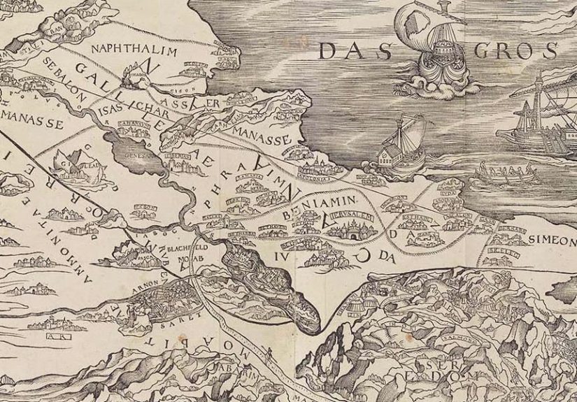
Some mistakes quietly disappear into history. Others get printed, bound into a Bible, preserved for 500 years, and then politely tap modern civilization on the shoulder as if to say, “By the way, I may have helped shape how you think about borders.” That is the strange, fascinating story of a Bible map from 1525: a woodcut map of the Holy Land associated with Lucas Cranach the Elder and printed in Zürich in Christopher Froschauer’s Old Testament.
The map had one very noticeable problem. It was printed backwards. The Mediterranean Sea appeared on the wrong side of Palestine, as if geography had looked in a mirror and decided to keep the outfit. Yet this backward Bible map was not merely a charming Renaissance blooper. According to modern scholarship, it helped change the way readers visualized Scripture, sacred land, territory, and eventually political borders.
That is the real twist. A map that got east and west wrong still helped readers think more concretely about place. It turned biblical stories into visual geography. It gave ordinary Bible readers a way to see the wilderness wanderings, the Promised Land, the Jordan River, Mount Carmel, Jericho, Nazareth, and the twelve tribal territories of ancient Israel. And once those places appeared as lines on a page, the page began doing more than explaining Scripture. It began shaping imagination.
The 1525 Bible Map: A Printing Error With a Long Afterlife
The first Bible to include a map of the Holy Land appeared in 1525, during the early years of the Swiss Reformation. It was published in Zürich by the printer Christoph Froschauer, whose press became closely associated with Reformation ideas. The map is commonly linked to Lucas Cranach the Elder, one of the leading artists and printmakers of the German Renaissance and a figure deeply connected to the visual culture of the Protestant Reformation.
Cranach was not a minor decorative name tossed onto a footnote for historical glitter. He was a major artist, a skilled printmaker, and a creator of images that helped define how many people saw the Reformation. His portraits of Martin Luther and other reformers became part of the visual vocabulary of Protestant Europe. So when a map connected with Cranach appeared inside a Bible, it represented more than a handy illustration. It was a union of theology, print technology, Renaissance design, and public education.
But then came the awkward cartographic hiccup: the map was reversed. In simple terms, it showed the Mediterranean Sea to the east of Palestine instead of the west. Today, that error would probably trigger a thousand social media posts, a few sarcastic geography teachers, and one extremely disappointed map nerd. In 1525, however, the mistake apparently slipped through. Many European readers and printers had limited firsthand knowledge of the eastern Mediterranean. The Holy Land was sacred, but for most people it was not familiar in the practical way a hometown, trade route, or nearby river might be familiar.
Why Put a Map in a Bible at All?
To modern readers, Bible maps feel normal. Open many study Bibles today and you may find maps of Abraham’s journeys, the Exodus route, the tribal allotments of Israel, Jerusalem in different periods, the ministry of Jesus, and Paul’s missionary journeys. They are so common that readers often forget they are interpretive tools, not part of the biblical text itself.
In 1525, that was not obvious. Adding a map to a Bible was innovative. It suggested that Scripture could be read not only as a sacred text but also as a book rooted in recognizable geography. The map made the biblical world look locatable. It helped readers imagine that events happened in real places with rivers, deserts, cities, mountains, and routes. In an age when printed books were expanding access to religious knowledge, that mattered enormously.
The Swiss Reformation emphasized close reading of Scripture. Reformers wanted believers to encounter the biblical text directly and seriously. At the same time, religious images were controversial in many Protestant settings. Traditional Catholic iconography, including images of saints and devotional art, could be criticized or removed. Maps, however, occupied a different category. They were not exactly idols, portraits, or altarpieces. They could be defended as educational, practical, and textual.
In other words, the map slipped through the front door wearing the respectable hat of “learning.” But once inside, it still did something emotionally powerful. It gave readers a visual devotional experience. Looking at the Holy Land on the page could become a kind of virtual pilgrimage. The reader’s eye could move from the Jordan River to Jericho, from wilderness stations to tribal lands, from places named in Scripture to the imagined landscape of salvation history.
The Older Medieval Roots Behind the Map
The 1525 map did not appear from thin air. It drew on older medieval traditions of mapping the Holy Land. Medieval Christian maps often treated geography as more than measurement. They blended physical place, sacred memory, pilgrimage, theology, and symbolic meaning. A map was not simply a device for getting from one town to another. It was also a visual argument about what the world meant.
One important influence was the tradition associated with Burchard of Mount Sion, a Dominican friar who described the Holy Land in the late thirteenth century. His work circulated widely and helped shape European ideas of biblical geography. Another influence came from Pietro Vesconte, a skilled medieval cartographer whose Holy Land maps were copied and adapted in later centuries. These earlier maps often used grids and clear divisions to represent the land.
The division of the Promised Land into the territories of the twelve tribes became especially important. In the biblical book of Joshua, chapters 13 through 19 describe allocations of land among tribes. Yet the biblical material is complex, and it does not always provide a neat, modern, surveyor-approved map. Ancient descriptions of boundaries, cities, inheritance, and tribal identity do not work like a modern GIS file. There are ambiguities, overlaps, and interpretive puzzles.
Maps helped simplify that complexity. They made the tribal lands look tidy. They transformed a difficult textual description into a visual arrangement. The problem is that tidy maps can be very persuasive. Once something appears as a clean line on a page, it can feel more certain than it really is.
From Sacred Inheritance to Political Borders
Here is where the story becomes bigger than one reversed map. In medieval Christian thought, the division of the Holy Land into tribal territories often carried spiritual meaning. The lines could symbolize inheritance, promise, sacred memory, and Christian claims to biblical history. They were not necessarily “borders” in the modern political sense. They did not mean passport control, national sovereignty, customs checkpoints, or a government office asking why you packed three jars of fig jam.
But from the late fifteenth century onward, European cartography was changing. The rediscovery and printing of Ptolemy’s geographical works influenced Renaissance mapmaking. Printed maps and atlases began to represent space in more systematic ways. Countries and regions increasingly appeared with boundary lines. The visual grammar of maps became more standardized, and readers learned to associate lines with territorial authority.
According to recent scholarly analysis, maps of the Holy Land were not simply following this new political habit. They may have helped lead it. Biblical maps that showed the twelve tribes as clearly bounded territories offered readers a powerful model: land could be divided into distinct, meaningful blocks. Those blocks could be associated with peoples. Those peoples could be imagined as belonging to bounded territories.
That is a major shift. A line that once suggested spiritual inheritance could gradually be read as political sovereignty. Sacred geography and political geography began speaking the same visual language. The Bible influenced early modern political imagination, while early modern political ideas influenced how people interpreted the Bible. The relationship was not one-way. It was a feedback loop, and like many feedback loops, it probably needed a good editor.
Why a Backwards Map Still Worked
At first glance, it seems odd that a reversed map could have such influence. Shouldn’t an inaccurate map fail? Not necessarily. Maps are powerful not only because they are accurate but because they organize attention. The 1525 Bible map gave readers a structure for imagining the Holy Land. Even with its reversed orientation, it made biblical geography visible, memorable, and repeatable.
Readers did not need the map to function like a modern navigational chart. They needed it to connect names, stories, and places. The wilderness wanderings became a route. The Promised Land became a divided landscape. The tribal allotments became visible territories. The sacred past became something the eye could travel through.
In that sense, the map’s backwardness is almost beside the point. Its influence came from placing a map inside a Bible and inviting readers to interpret Scripture spatially. It established a precedent. Later Bibles would include more maps. Publishers eventually standardized certain biblical map types, such as maps of the wilderness wanderings, the division of the land, the world of Jesus, and the journeys of Paul.
The 1525 map was a pioneer, even if it walked into history facing the wrong direction.
The Bible as a Changing Book Object
One of the most interesting lessons from this story is that the Bible, as a physical book, has changed over time. The sacred texts themselves have ancient roots, but the way readers encounter them has been shaped by format, translation, layout, commentary, headings, chapters, verses, illustrations, and maps.
Early biblical texts were not printed study Bibles with cross-references, footnotes, concordances, and a tasteful ribbon marker. The movement from scroll to codex changed reading habits. The development of portable single-volume Bibles changed access. The addition of chapter and verse divisions changed navigation. Reformation prefaces guided interpretation. Later typographical choices shaped how poetry and prophecy were read. Maps added yet another layer.
A map inside a Bible is not neutral. It tells readers, “This is where the story happened.” But it may also imply, “This is how the story should be organized.” That is helpful, but it can also be misleading if the visual simplification becomes stronger in the reader’s mind than the complexity of the text.
What the 1525 Map Teaches About Modern Borders
Modern people often treat borders as natural facts. We grow up looking at classroom maps where countries are colored in neat blocks: blue here, green there, orange over there, usually with no explanation for why one nation gets the soothing pastel shade and another gets aggressive mustard. Those lines can feel permanent, obvious, and ancient.
But borders are historical creations. Many are recent. Many have shifted repeatedly. Some were drawn through war, treaty, empire, colonization, negotiation, accident, or administrative convenience. Maps make those borders look clean, but life on the ground is often messier. Languages, families, trade routes, ecosystems, and cultures rarely stop politely at a line.
The 1525 Bible map reminds us that the way we visualize territory can shape what we think territory means. If people repeatedly see land divided into sacred or national blocks, they may begin to assume that the division is natural, ancient, or divinely approved. That is where careful interpretation becomes essential. Ancient texts do not always answer modern political questions in the simple way modern readers may want.
This does not mean maps are bad. Maps are brilliant tools. They help us learn, travel, compare, remember, and analyze. But maps are also arguments. They choose what to show and what to omit. They simplify. They frame. They can clarify reality or quietly rearrange it.
A Small Printing Mistake With a Big Cultural Lesson
The backward Bible map of 1525 is memorable because the error is so human. Somewhere in the chain of design, carving, printing, checking, and binding, the orientation went wrong. No one caught it, or no one who caught it had the power, money, or patience to fix it. Renaissance publishing was not a frictionless world of instant digital previews. Woodcuts required labor. Printing was expensive. Mistakes could survive because correcting them was not always simple.
Yet that mistake did not stop the map from mattering. In fact, it makes the story more useful. History is not shaped only by perfect inventions. It is also shaped by flawed tools that arrive at the right moment. The 1525 map appeared during a period of religious reform, expanding print culture, rising literacy, and changing political imagination. It gave readers a new way to see the Bible just as Europe was learning new ways to see space.
The result was not immediate world transformation in the cartoon sense. No one opened the 1525 Bible, gasped, and shouted, “Behold, the future nation-state!” History is rarely that tidy, even when maps pretend otherwise. The influence was slower and deeper. Bible maps became normal. Lines became meaningful. Sacred geography and territorial thinking grew closer. The visual habits of readers changed.
Experience and Reflection: What This Backwards Bible Map Feels Like Today
Studying the story of this Bible map feels a little like finding a typo in the first line of a famous speech and then realizing the typo somehow changed public speaking forever. At first, the reversed Mediterranean is funny. It is the kind of mistake that makes history feel refreshingly human. We tend to imagine Renaissance printers as serious men surrounded by ink, Latin, and stern eyebrows. But here they were, producing a groundbreaking Bible edition while accidentally flipping the Holy Land like a pancake.
That humor is useful because it invites curiosity. A reader may begin with the oddity“Wait, the first Bible map was backwards?”and then discover a much richer story about print culture, biblical interpretation, and political imagination. That is one of the best experiences history can offer: the tiny doorway that opens into a cathedral-sized room.
There is also a personal lesson in how visual aids shape understanding. Anyone who has studied the Bible, history, geography, or even family genealogy knows the feeling. A paragraph can be meaningful, but a map makes it click. Suddenly the Exodus has movement. Paul’s journeys have distance. Galilee, Judea, Samaria, and Jerusalem become spatial relationships rather than floating names. A map gives the mind a place to stand.
But the 1525 map also teaches caution. When a visual aid is persuasive, we may stop asking what it leaves out. A map can make uncertainty look settled. It can make interpretation look like fact. It can make ancient tribal inheritance look like modern national territory. The danger is not that readers use maps; the danger is that readers forget maps are interpretations.
This is especially relevant in a digital age. Today, we trust maps constantly. We follow GPS directions, zoom into satellite images, compare borders online, and use map apps to decide whether a restaurant is “basically nearby” or “emotionally in another country.” Digital maps feel authoritative because they are precise. But precision is not the same as neutrality. Every map still reflects choices: labels, borders, scale, color, emphasis, and purpose.
The backward Bible map is a beautiful reminder to stay humble before the page. It says that even influential tools can be flawed. It says that mistakes can travel far. It says that readers should be grateful for maps but not hypnotized by them. Most of all, it reminds us that the way information is presented can become almost as influential as the information itself.
There is something oddly encouraging in that. The 1525 map was not perfect, yet it mattered. It was wrong in orientation but right on time historically. It appeared when readers were hungry for direct engagement with Scripture, when printers were transforming Europe’s knowledge networks, and when mapmaking was becoming a central language of power. It did not need to be flawless to be consequential.
For writers, teachers, historians, and readers today, that is a useful thought. Our charts, illustrations, summaries, and explanations should be careful, but we should also recognize their power. A good visual can open a subject. A bad visual can distort one. A flawed but timely visual can change the conversation for centuries. The 1525 Bible map did all three at once, which is impressive for a piece of paper that could not even keep the Mediterranean on the correct side.
In the end, the map’s backwardness may be what keeps the story alive. It catches our attention, makes us smile, and then asks a serious question: How many of our “obvious” ideas were once choices made by printers, artists, theologians, scholars, and mapmakers? The answer is probably more than we think.
Conclusion
The Bible map from 1525 was a mistake, a milestone, and a mirror. It was printed backwards, yet it helped move biblical reading into a more visual and geographical age. It drew on medieval Holy Land traditions, entered the world through Reformation printing, and helped normalize the presence of maps inside Bibles. More importantly, it participated in a larger shift in how people imagined land, borders, inheritance, and political space.
Its legacy is not that a single reversed map invented modern borders by itself. History is far too complicated for that. Its legacy is subtler and more interesting: it shows how images inside books can shape the way people read texts, understand the world, and organize meaning. A backward map changed history not because it was accurate, but because it was influential.
That may be the perfect historical punchline. Sometimes the world is changed not by the people who get everything right, but by the people who print something wrong in exactly the right century.
SEO Tags
Note: This article is written in original American English for web publication and is based on synthesized historical research about the 1525 Holy Land Bible map, Reformation printing, biblical cartography, and the development of territorial border ideas.